Saint-Guy, Quebec
| Saint-Guy | |
|---|---|
| Municipality | |
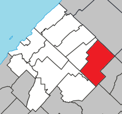 Location within Les Basques RCM | |
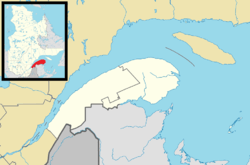 Saint-Guy Location in eastern Quebec | |
| Coordinates: 48°02′N 68°47′W / 48.033°N 68.783°WCoordinates: 48°02′N 68°47′W / 48.033°N 68.783°W[1] | |
| Country |
|
| Province |
|
| Region | Bas-Saint-Laurent |
| RCM | Les Basques |
| Constituted | January 1, 1958 |
| Government[2] | |
| • Mayor | Roger Rioux |
| • Federal riding |
Rimouski-Neigette—Témiscouata —Les Basques |
| • Prov. riding | Rivière-du-Loup-Témiscouata |
| Area[2][3] | |
| • Total | 143.10 km2 (55.25 sq mi) |
| • Land | 139.05 km2 (53.69 sq mi) |
| Population (2011)[3] | |
| • Total | 91 |
| • Density | 0.7/km2 (2/sq mi) |
| • Pop 2006-2011 |
|
| • Dwellings | 72 |
| Time zone | EST (UTC−5) |
| • Summer (DST) | EDT (UTC−4) |
| Postal code(s) | G0K 1W0 |
| Area code(s) | 418 and 581 |
| Highways |
|
Saint-Guy is a municipality in the Bas-Saint-Laurent region of Quebec, Canada.
Demographics
Population
| Canada census – Saint-Guy, Quebec community profile | |||
|---|---|---|---|
| 2011 | 2006 | 2001 | |
| Population: | 91 (+2.2% from 2006) | 89 (-16.0% from 2001) | 106 (-1.9% from 1996) |
| Land area: | 139.05 km2 (53.69 sq mi) | 139.05 km2 (53.69 sq mi) | 139.05 km2 (53.69 sq mi) |
| Population density: | 0.7/km2 (1.8/sq mi) | 0.6/km2 (1.6/sq mi) | 0.8/km2 (2.1/sq mi) |
| Median age: | 54.5 (M: 55.0, F: 54.2) | 57.2 (M: 56.5, F: 58.2) | 50.5 (M: 48.7, F: 51.0) |
| Total private dwellings: | 72 | 65 | 75 |
| Median household income: | $.N/A | $.N/A | $.N/A |
| Notes: Income data for this area has been suppressed for data quality or confidentiality reasons. – References: 2011[4] 2006[5] 2001[6] | |||
| Historical Census Data - Saint-Guy, Quebec[7] | ||
|---|---|---|
| Year | Pop. | ±% |
| 1991 | 157 | — |
| 1996 | 108 | −31.2% |
| 2001 | 106 | −1.9% |
| 2006 | 89 | −16.0% |
| 2011 | 91 | +2.2% |
Language
| Canada Census Mother Tongue - Saint-Guy, Quebec[7] | ||||||||||||||||||
|---|---|---|---|---|---|---|---|---|---|---|---|---|---|---|---|---|---|---|
| Census | Total | French |
English |
French & English |
Other | |||||||||||||
| Year | Responses | Count | Trend | Pop % | Count | Trend | Pop % | Count | Trend | Pop % | Count | Trend | Pop % | |||||
| 2011 |
95 |
90 | |
94.74% | 0 | |
0.00% | 5 | |
5.26% | 0 | |
0.00% | |||||
| 2006 |
80 |
80 | |
100.00% | 0 | |
0.00% | 0 | |
0.00% | 0 | |
0.00% | |||||
| 2001 |
95 |
95 | |
100.00% | 0 | |
0.00% | 0 | |
0.00% | 0 | |
0.00% | |||||
| 1996 |
95 |
95 | n/a | 100.00% | 0 | n/a | 0.00% | 0 | n/a | 0.00% | 0 | n/a | 0.00% | |||||
See also
References
- ↑ Reference number 56693 of the Commission de toponymie du Québec (French)
- 1 2 Geographic code 11020 in the official Répertoire des municipalités (French)
- 1 2 "(Code 2411020) Census Profile". 2011 census. Statistics Canada. 2012.
- ↑ "2011 Community Profiles". Canada 2011 Census. Statistics Canada. July 5, 2013. Retrieved 2014-03-10.
- ↑ "2006 Community Profiles". Canada 2006 Census. Statistics Canada. March 30, 2011. Retrieved 2014-03-10.
- ↑ "2001 Community Profiles". Canada 2001 Census. Statistics Canada. February 17, 2012. Retrieved 2014-03-10.
- 1 2 Statistics Canada: 1996, 2001, 2006, 2011 census
 |
Saint-Médard | |
Saint-Eugène-de-Ladrière | |
| Saint-Jean-de-Dieu | |
Esprit-Saint | ||
| ||||
| | ||||
| Sainte-Rita | Saint-Michel-du-Squatec | Lac-des-Aigles |
| Cities & Towns | |
|---|---|
| Municipalities | |
| Parishes | |
| Unorganized territories | |
| |
This article is issued from Wikipedia - version of the 1/5/2016. The text is available under the Creative Commons Attribution/Share Alike but additional terms may apply for the media files.