San Narciso, Quezon
| San Narciso | |
|---|---|
| Municipality | |
 | |
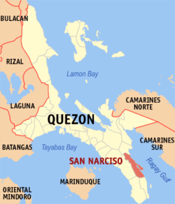 Map of Quezon showing the location of San Narciso | |
.svg.png) San Narciso Location within the Philippines | |
| Coordinates: 13°34′12″N 122°33′54″E / 13.57000°N 122.56500°ECoordinates: 13°34′12″N 122°33′54″E / 13.57000°N 122.56500°E | |
| Country | Philippines |
| Region | Calabarzon (Region IV-A) |
| Province | Quezon |
| District | 3rd district of Quezon |
| Formed | December 7, 1912 |
| Barangays | 24 |
| Government[1] | |
| • Mayor | Eleanor Umali Uy |
| • Vice Mayor | Raymond Nonnatus Rocha Medenilla |
| Area[2] | |
| • Total | 263.58 km2 (101.77 sq mi) |
| Population (2015)[3] | |
| • Total | 48,461 |
| • Density | 180/km2 (480/sq mi) |
| Time zone | PST (UTC+8) |
| ZIP code | 4313 |
| Dialing code | +63 (0)42 |
| Income class | 1st class |
| Website |
www |
San Narciso is a first class municipality in the province of Quezon, Philippines. According to the 2015 census, it has a population of 48,461 people.[3]
Barangays
San Narciso has 24 barangays, 4 in Poblacion area.
- Abuyon
- Andres Bonifacio
- Bani
- Binay
- Buenavista
- Busokbusokan
- Calwit
- Guinhalinan
- Lakdayan
- Maguiting
- Manlampong
- Pagkakaisa (Pob.)
- Maligaya (Pob.)
- Bayanihan (Pob.)
- Pagdadamayan (Pob.)
- Punta
- Rizal
- San Isidro
- San Juan
- San Vicente
- Vigo Central
- Villa Aurin (Pinagsama)
- Villa Reyes
- White Cliff
Demographics
| Population census of San Narciso | ||
|---|---|---|
| Year | Pop. | ±% p.a. |
| 1990 | 33,025 | — |
| 1995 | 36,535 | +1.91% |
| 2000 | 38,474 | +1.11% |
| 2007 | 39,828 | +0.48% |
| 2010 | 45,386 | +4.87% |
| 2015 | 48,461 | +1.26% |
| Source: Philippine Statistics Office[3] | ||
Local government
- Mayor: Eleanor "Allen" Umali Uy
- Vice Mayor: Raymond Nonnatus Rocha Medenilla
References
- ↑ "Official City/Municipal 2013 Election Results". Intramuros, Manila, Philippines: Commission on Elections (COMELEC). 11 September 2013. Retrieved 27 November 2013.
- ↑ "Province: QUEZON". PSGC Interactive. Makati City, Philippines: National Statistical Coordination Board. Retrieved 27 November 2013.
- 1 2 3 "Highlights of the Philippine Population 2015 Census of Population". 2015 Census of Population and Housing. Philippine Statistics Office. Retrieved 27 May 2016.
External links
- Philippine Standard Geographic Code
- Philippine Census Information
- Local Governance Performance Management System
 |
Buenavista | | ||
| Mulanay | |
Ragay Gulf Libmanan, Camarines Sur | ||
| ||||
| | ||||
| San Francisco | San Andres |
Lucena (capital) | |
| Municipalities |
|
| Component city | |
| Highly urbanized city |
|
This article is issued from Wikipedia - version of the 12/1/2016. The text is available under the Creative Commons Attribution/Share Alike but additional terms may apply for the media files.