Santa Isabel District
| Santa Isabel District | |
|---|---|
| District | |
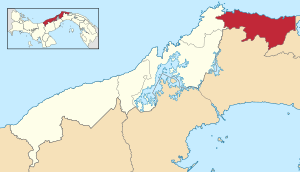 | |
 Santa Isabel District Location of the district capital in Panama | |
| Coordinates: 9°31′N 79°10′W / 9.517°N 79.167°WCoordinates: 9°31′N 79°10′W / 9.517°N 79.167°W | |
| Country |
|
| Province | Colón Province |
| Capital | Santa Isabel |
| Area | |
| • Total | 281 sq mi (729 km2) |
| Population (2000) | |
| • Total | 3,323 |
| Time zone | ETZ (UTC-5) |
Santa Isabel District (Spanish pronunciation: [ˈsanta isaˈβel]) is a district (distrito) of Colón Province in Panama. The population according to the 2000 census was 3,323.[1]The district covers a total area of 729 km². The capital lies at the city of Santa Isabel.[1]
Administrative divisions
The district is divided administratively into the following corregimientos:
Santa Isabel (capital), Palenque, Cuango, Miramar, Nombre de Dios, Palmira, Playa Chiquita and Viento Frío.
References
- 1 2 "Districts of Panama". Statoids. Retrieved April 11, 2009.
| Bocas del Toro Province | |
|---|---|
| Chiriquí Province | |
| Coclé Province | |
| Colón Province | |
| Darién Province | |
| Herrera Province | |
| Los Santos Province | |
| Panamá Province | |
| Veraguas Province | |
| West Panamá Province | |
This article is issued from Wikipedia - version of the 10/5/2015. The text is available under the Creative Commons Attribution/Share Alike but additional terms may apply for the media files.