Sele, Slovenj Gradec
| Sele | |
|---|---|
 | |
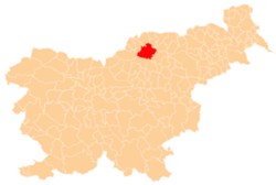
 Sele Location in Slovenia | |
| Coordinates: 46°30′10.96″N 15°0′57.78″E / 46.5030444°N 15.0160500°ECoordinates: 46°30′10.96″N 15°0′57.78″E / 46.5030444°N 15.0160500°E | |
| Country |
|
| Traditional region | Styria |
| Statistical region | Carinthia |
| Municipality | Slovenj Gradec |
| Area | |
| • Total | 11.43 km2 (4.41 sq mi) |
| Elevation | 639.6 m (2,098.4 ft) |
| Population (2002) | |
| • Total | 262 |
| [1] | |
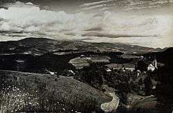
Sele (pronounced [ˈseːlɛ]) is a settlement in the City Municipality of Slovenj Gradec in northern Slovenia. The area was traditionally part of Styria. The entire municipality is now included in the Carinthia Statistical Region.[2]
The parish church in the settlement is dedicated to Saint Roch (Slovene: sveti Rok) and belongs to the Roman Catholic Archdiocese of Maribor. It dates to the late 15th century.[3] A second church in the east of the settlement dedicated to Saint Nicholas and was built in the early 14th century.[4]
References
- ↑ Statistical Office of the Republic of Slovenia
- ↑ Slovenj Gradec municipal site
- ↑ Slovenian Ministry of Culture register of national heritage reference number ešd 3337
- ↑ Slovenian Ministry of Culture register of national heritage reference number ešd 3339
External links
| Settlements | Administrative centre: Slovenj Gradec
|  | ||||||
|---|---|---|---|---|---|---|---|---|
| Landmarks |
| |||||||
| Notable people | ||||||||
This article is issued from Wikipedia - version of the 11/17/2016. The text is available under the Creative Commons Attribution/Share Alike but additional terms may apply for the media files.