Springstead, Wisconsin
| Springstead, Wisconsin | |
|---|---|
| Unincorporated community | |
 Springstead, Wisconsin  Springstead, Wisconsin | |
| Coordinates: 46°01′31″N 90°08′13″W / 46.02528°N 90.13694°WCoordinates: 46°01′31″N 90°08′13″W / 46.02528°N 90.13694°W | |
| Country | United States |
| State | Wisconsin |
| County | Iron |
| Elevation | 1,621 ft (494 m) |
| Time zone | Central (CST) (UTC-6) |
| • Summer (DST) | CDT (UTC-5) |
| Area code(s) | 715 & 534 |
| GNIS feature ID | 1577834[1] |
Springstead is an unincorporated community located, in the town of Sherman, in Iron County, Wisconsin, United States. Springstead is located on Wisconsin Highway 182 16 miles (26 km) east-northeast of Park Falls.
References
Municipalities and communities of Iron County, Wisconsin, United States | ||
|---|---|---|
| Cities | 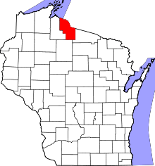 | |
| Towns | ||
| CDPs | ||
| Unincorporated communities | ||
| Indian reservations | ||
| Footnotes | ‡This populated place also has portions in an adjacent county or counties | |
This article is issued from Wikipedia - version of the 7/29/2016. The text is available under the Creative Commons Attribution/Share Alike but additional terms may apply for the media files.