Starks, Louisiana
| Starks, Louisiana | |
|---|---|
| Census-designated place | |
 Starks Location within Louisiana | |
| Coordinates: 30°18′55″N 93°39′42″W / 30.31528°N 93.66167°WCoordinates: 30°18′55″N 93°39′42″W / 30.31528°N 93.66167°W | |
| Country |
|
| State |
|
| Parish | Calcasieu |
| Area | |
| • Total | 8.9 km2 (3.4 sq mi) |
| • Land | 8.9 km2 (3.4 sq mi) |
| • Water | 0 km2 (0 sq mi) |
| Elevation | 9 m (31 ft) |
| Population (2010) | 664 |
| • Density | 74.8/km2 (194/sq mi) |
| Time zone | CST (UTC-6) |
| • Summer (DST) | CST (UTC-5) |
| ZIP Codes | 70661 |
| Area Code | 337 |
Starks is an unincorporated community and census-designated place (CDP) in Calcasieu Parish, Louisiana, United States. As of the 2010 census it had a population of 664.[1] It is located approximately 30 miles (48 km) northwest of Lake Charles and about 5 miles (8 km) from the Texas and Louisiana border. Starks is known for its annual Mayhaw Festival to celebrate the fruit that grows in the bayous along the Texas/Louisiana border.
References
- ↑ "Geographic Identifiers: 2010 Demographic Profile Data (G001): Starks CDP, Louisiana". U.S. Census Bureau, American Factfinder. Retrieved August 15, 2014.
External links
Municipalities and communities of Calcasieu Parish, Louisiana, United States | ||
|---|---|---|
| Cities | 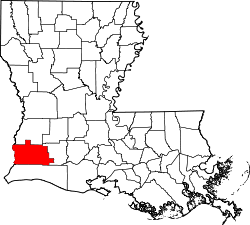 | |
| Towns | ||
| CDPs | ||
| Other unincorporated communities | ||
This article is issued from Wikipedia - version of the 10/17/2014. The text is available under the Creative Commons Attribution/Share Alike but additional terms may apply for the media files.