State road D110 (Turkey)
| D.110 | |
|---|---|
| Route information | |
|
Part of | |
| Length: | 172 km (107 mi) |
| Major junctions | |
| West end: | İpsala checkpoint at the Greek border crossing in Edirne Province |
| East end: |
Kınalı, Silivri, Istanbul |
| Highway system | |
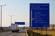
West end of D-110: Ipsala Checkpoint at Greece–Turkey border crossing
East end of D-110:Kınalı junction in Silivri district of Istanbul Province
D.110 is a west-to-east state road in Turkey. It starts at İpsala checkpoint at the Greece–Turkey border crossing in Edirne Province, and ends in Kınalı, Silivri, Istanbul joining the ![]() . It crosses the north to south state roads
. It crosses the north to south state roads ![]() ,
, ![]() and
and ![]() along its course.[1]
along its course.[1]
Itinerary
| Province | Location | Distance from (km) | ||
|---|---|---|---|---|
| previous location | Ipsala | Kınalı | ||
| Edirne | ||||
| Ipsala Checkpoint at Greece–Turkey border crossing | 0 | 0 | 172 | |
| Ipsala | 6 | 6 | 166 | |
| Keşan | 23 | 29 | 143 | |
| Tekirdağ | Malkara | 23 | 52 | 120 |
| Tekirdağ | 61 | 113 | 59 | |
| Marmara Ereğlisi | 40 | 153 | 19 | |
| Istanbul | Kınalı | 19 | 172 | 0 |
| 1.000 mi = 1.609 km; 1.000 km = 0.621 mi | ||||
Intersections
See also
References
- ↑ Türkiye Haritası (Map) (in Turkish). Karayolları Genel Müdürlüğü. Retrieved 2015-06-16.
External links
| West–east highways |
| ||||||
|---|---|---|---|---|---|---|---|
| North–south highways |
| ||||||
This article is issued from Wikipedia - version of the 2/10/2016. The text is available under the Creative Commons Attribution/Share Alike but additional terms may apply for the media files.