Stroud, Alabama
| Stroud, Alabama | |
|---|---|
| Unincorporated community | |
 Stroud, Alabama  Stroud, Alabama | |
| Coordinates: 33°03′17″N 85°19′51″W / 33.05472°N 85.33083°WCoordinates: 33°03′17″N 85°19′51″W / 33.05472°N 85.33083°W | |
| Country | United States |
| State | Alabama |
| County | Chambers |
| Elevation | 846 ft (258 m) |
| Time zone | Central (CST) (UTC-6) |
| • Summer (DST) | CDT (UTC-5) |
| Area code(s) | 334 |
| GNIS feature ID | 127474[1] |
Stroud is an unincorporated community in Chambers County, Alabama, United States, located along U.S. Route 431. Stroud was home to James Wyly Grady, who served in the Alabama Legislature.[2] A post office operated under the name Stroud from 1882 to 1957.[3]
Demographics
| Historical population | |||
|---|---|---|---|
| Census | Pop. | %± | |
| 1890 | 285 | — | |
| 1920 | 442 | — | |
| 1930 | 396 | −10.4% | |
| 1940 | 125 | −68.4% | |
| 1950 | 79 | −36.8% | |
| U.S. Decennial Census[4] | |||
References
- ↑ "Stroud". Geographic Names Information System. United States Geological Survey.
- ↑ Alabama. Department of Archives and History (1915). Alabama Official and Statistical Register. Brown Printing Company. p. 104.
- ↑ "Chambers County". Jim Forte Postal History. Retrieved 1 January 2015.
- ↑ "U.S. Decennial Census". Census.gov. Retrieved June 6, 2013.
External links
Municipalities and communities of Chambers County, Alabama, United States | ||
|---|---|---|
| Cities | 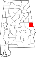 | |
| Towns | ||
| CDPs | ||
| Unincorporated communities | ||
| Ghost town | ||
| Footnotes | ‡This populated place also has portions in an adjacent county or counties | |
This article is issued from Wikipedia - version of the 11/4/2016. The text is available under the Creative Commons Attribution/Share Alike but additional terms may apply for the media files.