Stumpy Point, North Carolina
| Stumpy Point, North Carolina | |
|---|---|
| Unincorporated community | |
 Stumpy Point Location within the state of North Carolina | |
| Coordinates: 35°41′54″N 75°44′27″W / 35.69833°N 75.74083°WCoordinates: 35°41′54″N 75°44′27″W / 35.69833°N 75.74083°W | |
| Country | United States |
| State | North Carolina |
| County | Dare County |
| Elevation | 3 ft (0.9144 m) |
| Time zone | Eastern (EST) (UTC-5) |
| • Summer (DST) | EDT (UTC-4) |
| ZIP code | 27978 |
| Area code(s) | 252 |
Stumpy Point is an unincorporated community in Dare County, North Carolina, United States.[1] The community is located at the intersection of US 264 and Bayview Drive; along the north side of Stumpy Point Bay. It is surrounded by the Alligator River National Wildlife Refuge.
The town is mentioned in the sci-fi novel Ender's Game by Orson Scott Card, in which the little town is razed sometime in the future to build a spaceport in Pamlico Sound, and the spaceport is unofficially named after Stumpy Point.
References
Municipalities and communities of Dare County, North Carolina, United States | ||
|---|---|---|
| Towns | 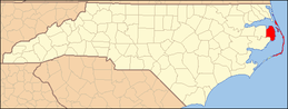 | |
| CDPs | ||
| Unincorporated communities | ||
This article is issued from Wikipedia - version of the 11/24/2015. The text is available under the Creative Commons Attribution/Share Alike but additional terms may apply for the media files.