Subprefecture of Pirituba-Jaraguá
| Subprefecture of Pirituba-Jaraguá | |
|---|---|
| Subprefecture | |
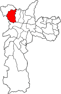 Location of the Subprefecture of Pirituba-Jaraguá in São Paulo | |
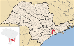 Location of municipality of São Paulo within the State of São Paulo | |
| Country |
|
| Region | Southeast |
| State |
|
| Municipality |
|
| Administrative Zone | Northwest |
| Districts | Pirituba, São Domingos, Jaraguá |
| Government | |
| • Type | Subprefecture |
| • Subprefect | Sergio Carlos Filho |
| Area | |
| • Total | 55.05 km2 (21.25 sq mi) |
| Population (2008) | |
| • Total | 442,722 |
| Website | Subprefeitura Pirituba-Jaraguá (Portuguese) |
The Subprefecture of Pirituba-Jaraguá is one of 31 subprefectures of the city of São Paulo, Brazil. It comprises three districts: Pirituba, São Domingos, and Jaraguá.[1] The highest point of the municipality of São Paulo, Pico do Jaraguá, is located in this place. It's also where the roads connecting Campinas and the Central-West region of Brazil have the start point.
References
Coordinates: 23°28′30″S 46°43′25″W / 23.47500°S 46.72361°W
This article is issued from Wikipedia - version of the 11/5/2016. The text is available under the Creative Commons Attribution/Share Alike but additional terms may apply for the media files.