Sucarnoochee, Mississippi
| Sucarnoochee, Mississippi | |
|---|---|
| Unincorporated community | |
 Sucarnoochee, Mississippi  Sucarnoochee, Mississippi | |
| Coordinates: 32°43′52″N 88°28′23″W / 32.73111°N 88.47306°WCoordinates: 32°43′52″N 88°28′23″W / 32.73111°N 88.47306°W | |
| Country | United States |
| State | Mississippi |
| County | Kemper |
| Elevation | 223 ft (68 m) |
| Time zone | Central (CST) (UTC-6) |
| • Summer (DST) | CDT (UTC-5) |
| GNIS feature ID | 678379[1] |
Sucarnoochee is an unincorporated community in Kemper County, Mississippi, United States. Its post office [2] has been closed. It was also known as Sucarnooche.
The community was named from its location near the Sucarnoochee River.[3]
References
- ↑ "Sucarnoochee". Geographic Names Information System. United States Geological Survey.
- ↑ "Sucarnoochee Mississippi post office". Geographic Names Information System. United States Geological Survey.
- ↑ Baca, Keith A. (1 June 2007). Native American place names in Mississippi. University Press of Mississippi. p. 98. ISBN 978-1-57806-954-5.
Municipalities and communities of Kemper County, Mississippi, United States | ||
|---|---|---|
| Towns | 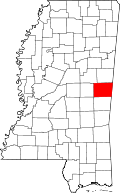 | |
| CDP | ||
| Other communities |
| |
| Ghost town | ||
| Footnotes | ‡This populated place also has portions in an adjacent county or counties | |
This article is issued from Wikipedia - version of the 10/13/2016. The text is available under the Creative Commons Attribution/Share Alike but additional terms may apply for the media files.