The Devils Bow, Kentucky
| The Devils Bow | |
|---|---|
| Unincorporated community | |
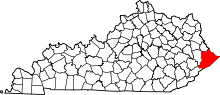
 The Devils Bow  The Devils Bow Location within the state of Kentucky | |
| Coordinates: 37°40′43″N 82°32′52″W / 37.67861°N 82.54778°WCoordinates: 37°40′43″N 82°32′52″W / 37.67861°N 82.54778°W | |
| Country | United States |
| State | Kentucky |
| County | Pike |
| Elevation | 755 ft (230 m) |
| Time zone | Eastern (EST) (UTC-5) |
| • Summer (DST) | EDT (UTC-4) |
| GNIS feature ID | 2337066[1] |
The Devils Bow was an unincorporated community in Pike County, Kentucky, United States.
References
This article is issued from Wikipedia - version of the 7/27/2016. The text is available under the Creative Commons Attribution/Share Alike but additional terms may apply for the media files.