Tokmak, Zaporizhia Oblast
| Токмак Токмак | |||
|---|---|---|---|
|
Historical merchant's building in Tokmak | |||
| |||
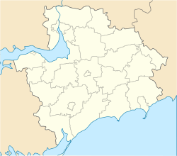 Токмак Location of Tokmak | |||
| Coordinates: 47°15′N 35°42′E / 47.250°N 35.700°ECoordinates: 47°15′N 35°42′E / 47.250°N 35.700°E | |||
| Country Oblast Raion |
Tokmatskyi Raion | ||
| Area | |||
| • Land | 32.46 km2 (12.53 sq mi) | ||
| Population (2013) | |||
| • Total | 32,996 | ||
| Postal code | 71700 | ||
| Area code(s) | +380 6178 | ||
| Climate | Dfa | ||
| Website | http://tokmakcity.org.ua | ||
.JPG)

Tokmak (Ukrainian: Токмак), a city in the Zaporizhia Oblast (province) of south-central Ukraine, stands on the River Tokmachka, a tributary of the River Tokmak. Serving as the administrative center of the Tokmak Raion (district), Tokmak is incorporated as a city of oblast significance and does not belong to the raion. Population: 32,996 (2013 est.)[1].
Points of interest
Gallery
.JPG) Ruins of a mill in Tokmak
Ruins of a mill in Tokmak.JPG) Diesel machine monument
Diesel machine monument.JPG) WW2 memorial in Tokmak
WW2 memorial in Tokmak.JPG) A market street in Tokmak
A market street in Tokmak_(YDS_8437).JPG) St. Sergius of Radonezh church
St. Sergius of Radonezh church.JPG) Former bank building
Former bank building.JPG) Ascension Church
Ascension Church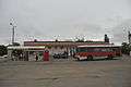 Tokmak bus station
References
- ↑ "Чисельність наявного населення України (Actual population of Ukraine)" (in Ukrainian). State Statistics Service of Ukraine. Retrieved 21 January 2015.
| Raions | |||||||
|---|---|---|---|---|---|---|---|
| Cities |
| ||||||
| |||||||
This article is issued from Wikipedia - version of the 9/8/2016. The text is available under the Creative Commons Attribution/Share Alike but additional terms may apply for the media files.