Toll Gate, West Virginia
| Toll Gate, West Virginia | |
|---|---|
| Unincorporated community | |
 Toll Gate, West Virginia  Toll Gate, West Virginia | |
| Coordinates: 39°16′21″N 80°54′54″W / 39.27250°N 80.91500°WCoordinates: 39°16′21″N 80°54′54″W / 39.27250°N 80.91500°W | |
| Country | United States |
| State | West Virginia |
| County | Ritchie |
| Elevation | 804 ft (245 m) |
| Time zone | Eastern (EST) (UTC-5) |
| • Summer (DST) | EDT (UTC-4) |
| ZIP codes | 26442 |
| Area code(s) | 304 & 681 |
| GNIS feature ID | 1555815[1] |
Toll Gate is an unincorporated community in Ritchie County, West Virginia, United States. Toll Gate is 3 miles (4.8 km) east-southeast of Pennsboro.
The community was named after a tollgate near the original town site.[2]
References
- ↑ "Toll Gate". Geographic Names Information System. United States Geological Survey.
- ↑ Kenny, Hamill (1945). West Virginia Place Names: Their Origin and Meaning, Including the Nomenclature of the Streams and Mountains. Piedmont, WV: The Place Name Press. p. 628.
Municipalities and communities of Ritchie County, West Virginia, United States | ||
|---|---|---|
| City | 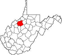 | |
| Towns | ||
| Unincorporated communities |
| |
| Ghost towns | ||
| Footnotes | ‡This populated place also has portions in an adjacent county or counties | |
This article is issued from Wikipedia - version of the 7/28/2016. The text is available under the Creative Commons Attribution/Share Alike but additional terms may apply for the media files.