Tookland, Virginia
| Tookland, Virginia | |
|---|---|
| Unincorporated community | |
 Tookland, Virginia  Tookland, Virginia | |
| Coordinates: 37°15′01″N 82°06′30″W / 37.25028°N 82.10833°WCoordinates: 37°15′01″N 82°06′30″W / 37.25028°N 82.10833°W | |
| Country | United States |
| State | Virginia |
| County | Buchanan |
| Elevation | 1,083 ft (330 m) |
| Time zone | Eastern (EST) (UTC-5) |
| • Summer (DST) | EDT (UTC-4) |
| Area code(s) | 276 |
| GNIS feature ID | 1496319[1] |
Tookland is an unincorporated community in Buchanan County, Virginia, United States. Tookland is located on U.S. Route 460 and Virginia State Route 83 2 miles (3.2 km) south of Grundy.
References
Municipalities and communities of Buchanan County, Virginia, United States | ||
|---|---|---|
| Town | 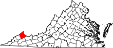 | |
| CDP | ||
| Unincorporated communities |
| |
| Footnotes | ‡This populated place also has portions in an adjacent county or counties | |
This article is issued from Wikipedia - version of the 7/27/2016. The text is available under the Creative Commons Attribution/Share Alike but additional terms may apply for the media files.