Uniontown, Arkansas
| Uniontown, Arkansas | |
|---|---|
| Unincorporated community | |
 Uniontown, Arkansas  Uniontown, Arkansas | |
| Coordinates: 35°35′04″N 94°26′39″W / 35.58444°N 94.44417°WCoordinates: 35°35′04″N 94°26′39″W / 35.58444°N 94.44417°W | |
| Country | United States |
| State | Arkansas |
| County | Crawford |
| Elevation | 866 ft (264 m) |
| Time zone | Central (CST) (UTC-6) |
| • Summer (DST) | CDT (UTC-5) |
| ZIP code | 72955 |
| Area code(s) | 479 |
| GNIS feature ID | 78629[1] |
Uniontown is an unincorporated community in Crawford County, Arkansas, United States. Henry Howell (1812-1883) was the founder of Uniontown, Arkansas where he farmed until his death on June 27, 1883. He was constable and deputy sheriff. Henry was married to Martha (Low) Howell (1813-1903) known as "Granny Howell" to all. Uniontown is located on Arkansas Highway 220 near the Oklahoma border, 4.5 miles (7.2 km) west-northwest of Cedarville. Uniontown has a post office with ZIP code 72955.[2] Slack-Comstock-Marshall Farm, which is listed on the National Register of Historic Places, is located in the community.[3]
References
- ↑ U.S. Geological Survey Geographic Names Information System: Uniontown, Arkansas
- ↑ ZIP Code Lookup Archived June 15, 2011, at the Wayback Machine.
- ↑ National Park Service (2009-03-13). "National Register Information System". National Register of Historic Places. National Park Service.
Municipalities and communities of Crawford County, Arkansas, United States | ||
|---|---|---|
| Cities | 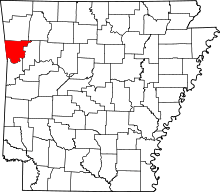 | |
| Towns | ||
| Unincorporated communities | ||
This article is issued from Wikipedia - version of the 11/13/2016. The text is available under the Creative Commons Attribution/Share Alike but additional terms may apply for the media files.