Vallscreek, West Virginia
| Vallscreek | |
|---|---|
| Unincorporated community | |
 Vallscreek  Vallscreek Location within West Virginia | |
| Coordinates: 37°13′55″N 81°38′42″W / 37.23194°N 81.64500°WCoordinates: 37°13′55″N 81°38′42″W / 37.23194°N 81.64500°W | |
| Country | United States |
| State | West Virginia |
| County | McDowell |
| Elevation | 1,598 ft (487 m) |
| Time zone | Eastern (EST) (UTC-5) |
| • Summer (DST) | EDT (UTC-4) |
| Zip codes | 24890 |
| Area code(s) | 304 & 681 |
| GNIS feature ID | 1555874[1] |
Vallscreek is an unincorporated community in McDowell County, West Virginia, United States. Vallscreek is 5.5 miles (8.9 km) south-southeast of War. It was also known as Hartwell.
The community takes its name from nearby Vall Creek.[2]
References
- ↑ U.S. Geological Survey Geographic Names Information System: Vallscreek, West Virginia
- ↑ Kenny, Hamill (1945). West Virginia Place Names: Their Origin and Meaning, Including the Nomenclature of the Streams and Mountains. Piedmont, WV: The Place Name Press. p. 642.
Municipalities and communities of McDowell County, West Virginia, United States | ||
|---|---|---|
| Cities | 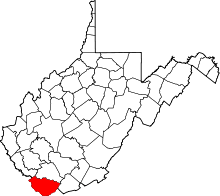 | |
| Towns | ||
| CDPs | ||
| Unincorporated communities |
| |
| Ghost town | ||
| Footnotes | ‡This populated place also has portions in an adjacent county or counties | |
This article is issued from Wikipedia - version of the 7/28/2016. The text is available under the Creative Commons Attribution/Share Alike but additional terms may apply for the media files.