Wienerwald, Austria
| Wienerwald | ||
|---|---|---|
| ||
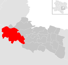
 Wienerwald Location within Austria | ||
| Coordinates: 48°6′N 16°8′E / 48.100°N 16.133°ECoordinates: 48°6′N 16°8′E / 48.100°N 16.133°E | ||
| Country | Austria | |
| State | Lower Austria | |
| District | Mödling | |
| Government | ||
| • Mayor | Michael Krischke | |
| Area | ||
| • Total | 48.16 km2 (18.59 sq mi) | |
| Elevation | 340 m (1,120 ft) | |
| Population (1 January 2016)[1] | ||
| • Total | 2,650 | |
| • Density | 55/km2 (140/sq mi) | |
| Time zone | CET (UTC+1) | |
| • Summer (DST) | CEST (UTC+2) | |
| Postal code | 2392 | |
| Area code | 02238 | |
| Website | www.wienerwald.org | |

Municipality Wienerwald
Wienerwald is a Municipality in the district of Mödling in the Austrian state of Lower Austria. It is named after the forest Wienerwald.
Villages
- Ameisbühel
- Buchelbach
- Dornbach
- Festleiten
- Grub
- Gruberau
- Lindenhof
- Rohrberg
- Sittendorf
- Stangau
- Sulz im Wienerwald is the main town.
- Vogelgraben
- Wöglerin
Population
| Historical population | ||
|---|---|---|
| Year | Pop. | ±% |
| 1971 | 1,381 | — |
| 1981 | 1,553 | +12.5% |
| 1991 | 1,996 | +28.5% |
| 2001 | 2,409 | +20.7% |
| 2011 | 2,479 | +2.9% |
Sights
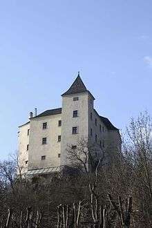
Wildegg Castle
- Wildegg Castle in Sittendorf
References
External links
| Wikimedia Commons has media related to Wienerwald (Gemeinde). |
This article is issued from Wikipedia - version of the 12/30/2015. The text is available under the Creative Commons Attribution/Share Alike but additional terms may apply for the media files.