Yorktown, Arkansas
| Yorktown, Arkansas | |
|---|---|
| Unincorporated community | |
 Yorktown, Arkansas  Yorktown, Arkansas | |
| Coordinates: 34°01′15″N 91°49′00″W / 34.02083°N 91.81667°WCoordinates: 34°01′15″N 91°49′00″W / 34.02083°N 91.81667°W | |
| Country | United States |
| State | Arkansas |
| County | Lincoln |
| Elevation | 184 ft (56 m) |
| Time zone | Central (CST) (UTC-6) |
| • Summer (DST) | CDT (UTC-5) |
| ZIP code | 71678 |
| Area code(s) | 870 |
| GNIS feature ID | 56609[1] |
Yorktown is an unincorporated community in Lincoln County, Arkansas, United States. Yorktown is located along Bayou Bartholomew and U.S. Route 425 6 miles (9.7 km) north-northeast of Star City.[2] Yorktown has a post office with ZIP code 71678.[3]
References
- ↑ U.S. Geological Survey Geographic Names Information System: Yorktown, Arkansas
- ↑ Lincoln County, Arkansas General Highway Map (PDF) (Map). Arkansas State Highway and Transportation Department. 2010. Retrieved 2011-06-02.
- ↑ ZIP Code Lookup Archived September 14, 2012, at the Wayback Machine.
Municipalities and communities of Lincoln County, Arkansas, United States | ||
|---|---|---|
| Cities | 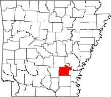 | |
| Unincorporated communities | ||
This article is issued from Wikipedia - version of the 11/17/2016. The text is available under the Creative Commons Attribution/Share Alike but additional terms may apply for the media files.