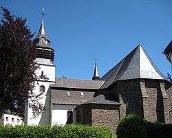
Arzfeld
| Arzfeld | ||
|---|---|---|
 | ||
| ||
 Arzfeld | ||
Location of Arzfeld within Eifelkreis Bitburg-Prüm district 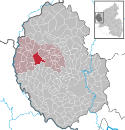 | ||
| Coordinates: 50°5′20″N 6°16′31″E / 50.08889°N 6.27528°ECoordinates: 50°5′20″N 6°16′31″E / 50.08889°N 6.27528°E | ||
| Country | Germany | |
| State | Rhineland-Palatinate | |
| District | Eifelkreis Bitburg-Prüm | |
| Municipal assoc. | Arzfeld | |
| Government | ||
| • Mayor | Andreas Kruppert (CDU) | |
| Area | ||
| • Total | 19.38 km2 (7.48 sq mi) | |
| Population (2015-12-31)[1] | ||
| • Total | 1,346 | |
| • Density | 69/km2 (180/sq mi) | |
| Time zone | CET/CEST (UTC+1/+2) | |
| Postal codes | 54687 | |
| Dialling codes | 06550 | |
| Vehicle registration | BIT | |
| Website | www.vg-arzfeld.de | |

Arzfeld is a municipality in the district Bitburg-Prüm, in Rhineland-Palatinate, Germany. It is situated in the Eifel, near the border with Luxembourg, approx. 20 km north-west of Bitburg and 25 km south-east of Sankt-Vith.
Arzfeld is the seat of the Verbandsgemeinde ("collective municipality") Arzfeld.
References
- ↑ "Gemeinden in Deutschland mit Bevölkerung am 31. Dezember 2015" (PDF). Statistisches Bundesamt (in German). 2016.
This article is issued from Wikipedia - version of the 6/21/2015. The text is available under the Creative Commons Attribution/Share Alike but additional terms may apply for the media files.