Baie-des-Sables, Quebec
| Baie-des-Sables | |
|---|---|
| Municipality | |
 | |
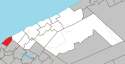 Location within La Matanie RCM. | |
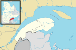 Baie-des-Sables Location in eastern Quebec. | |
| Coordinates: 48°43′N 67°51′W / 48.717°N 67.850°WCoordinates: 48°43′N 67°51′W / 48.717°N 67.850°W[1] | |
| Country |
|
| Province |
|
| Region | Bas-Saint-Laurent |
| RCM | La Matanie |
| Constituted | January 1, 1859 |
| Government[2] | |
| • Mayor | Denis Santerre |
| • Federal riding | Haute-Gaspésie—La Mitis—Matane—Matapédia |
| • Prov. riding | Matane-Matapédia |
| Area[2][3] | |
| • Total | 64.80 km2 (25.02 sq mi) |
| • Land | 65.48 km2 (25.28 sq mi) |
|
There is an apparent contradiction between two authoritative sources | |
| Population (2011)[3] | |
| • Total | 609 |
| • Density | 9.3/km2 (24/sq mi) |
| • Pop 2006-2011 |
|
| • Dwellings | 277 |
| Time zone | EST (UTC−5) |
| • Summer (DST) | EDT (UTC−4) |
| Postal code(s) | G0J 1C0 |
| Area code(s) | 418 and 581 |
| Highways |
|
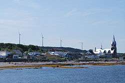
Baie-des-Sables is a municipality in La Matanie Regional County Municipality in the Bas-Saint-Laurent region of Quebec, Canada.
Its elevation is 577 ft.
Demographics
| Canada census – Baie-des-Sables, Quebec community profile | |||
|---|---|---|---|
| 2011 | 2006 | 2001 | |
| Population: | 609 (-0.8% from 2006) | 614 (-6.1% from 2001) | 654 (-0.5% from 1996) |
| Land area: | 65.48 km2 (25.28 sq mi) | 65.48 km2 (25.28 sq mi) | 65.48 km2 (25.28 sq mi) |
| Population density: | 9.3/km2 (24/sq mi) | 9.4/km2 (24/sq mi) | 10.0/km2 (26/sq mi) |
| Median age: | 48.5 (M: 47.5, F: 48.96) | 45.9 (M: 46.0, F: 45.8) | 43.0 (M: 42.8, F: 43.4) |
| Total private dwellings: | 277 | 327 | 321 |
| Median household income: | $48,415 | $38,832 | $33,373 |
| Notes: Population in 1996: 657[4] (-5.9% from 1991) - Population in 1991: 698[4] – References: 2011[5] 2006[6] 2001[7] | |||
See also
References
- ↑ Reference number 3060 of the Commission de toponymie du Québec (French)
- 1 2 "Baie-des-Sables". Répertoire des municipalités (in French). Ministère des Affaires municipales, des Régions et de l'Occupation du territoire. Retrieved 2012-01-24.
- 1 2 "Baie-des-Sables census profile". 2011 Census data. Statistics Canada. Retrieved 2012-01-24.
- 1 2 "Electronic Area Profiles". Canada 1996 Census. Statistics Canada. Retrieved 2013-05-18.
- ↑ "2011 Community Profiles". Canada 2011 Census. Statistics Canada. July 5, 2013. Retrieved 2014-01-29.
- ↑ "2006 Community Profiles". Canada 2006 Census. Statistics Canada. March 30, 2011. Retrieved 2012-01-24.
- ↑ "2001 Community Profiles". Canada 2001 Census. Statistics Canada. February 17, 2012. Retrieved 2012-01-24.
| Wikimedia Commons has media related to Baie-des-Sables. |
 |
Pointe-Lebel Saint Lawrence River |
| ||
| Métis-sur-Mer | |
Saint-Ulric | ||
| ||||
| | ||||
| Saint-Damase |
| Cities & Towns | |
|---|---|
| Municipalities | |
| Parishes | |
| Unorganized territories | |
| |
This article is issued from Wikipedia - version of the 12/25/2015. The text is available under the Creative Commons Attribution/Share Alike but additional terms may apply for the media files.