Sainte-Paule, Quebec
| Sainte-Paule | |
|---|---|
| Municipality | |
 | |
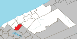 Location within La Matanie RCM. | |
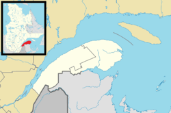 Sainte-Paule Location in eastern Quebec. | |
| Coordinates: 48°40′N 67°33′W / 48.667°N 67.550°WCoordinates: 48°40′N 67°33′W / 48.667°N 67.550°W[1] | |
| Country |
|
| Province |
|
| Region | Bas-Saint-Laurent |
| RCM | La Matanie |
| Constituted | January 1, 1968 |
| Government[2] | |
| • Mayor | Yvan Côté |
| • Federal riding | Haute-Gaspésie—La Mitis—Matane—Matapédia |
| • Prov. riding | Matane-Matapédia |
| Area[2][3] | |
| • Total | 87.20 km2 (33.67 sq mi) |
| • Land | 83.41 km2 (32.20 sq mi) |
| Population (2011)[3] | |
| • Total | 201 |
| • Density | 2.4/km2 (6/sq mi) |
| • Pop 2006-2011 |
|
| • Dwellings | 186 |
| Time zone | EST (UTC−5) |
| • Summer (DST) | EDT (UTC−4) |
| Postal code(s) | G0J 3C0 |
| Area code(s) | 418 and 581 |
| Highways | No major routes |
| Website |
www |
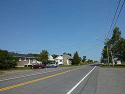
Sainte-Paule is a municipality in Quebec, Canada.
Demographics
Population
| Canada census – Sainte-Paule, Quebec community profile | |||
|---|---|---|---|
| 2011 | 2006 | 2001 | |
| Population: | 201 (-12.2% from 2006) | 229 (+15.1% from 2001) | 199 (-12.7% from 1996) |
| Land area: | 83.41 km2 (32.20 sq mi) | 83.41 km2 (32.20 sq mi) | 84.86 km2 (32.76 sq mi) |
| Population density: | 2.4/km2 (6.2/sq mi) | 2.7/km2 (7.0/sq mi) | 2.3/km2 (6.0/sq mi) |
| Median age: | 55.9 (M: 56.5, F: 55.5) | 53.1 (M: 54.1, F: 52.7) | 45.7 (M: 46.5, F: 44.0) |
| Total private dwellings: | 186 | 182 | 85 |
| Median household income: | $.N/A | $.N/A | $.N/A |
| Notes: Income data for this area has been suppressed for data quality or confidentiality reasons. – References: 2011[3] 2006[4] 2001[5] | |||
| Historical Census Data - Sainte-Paule, Quebec[6] | ||||||||||||||||||||||||||||||||||
|---|---|---|---|---|---|---|---|---|---|---|---|---|---|---|---|---|---|---|---|---|---|---|---|---|---|---|---|---|---|---|---|---|---|---|
|
|
|
|
| ||||||||||||||||||||||||||||||
See also
References
- ↑ Reference number 56360 of the Commission de toponymie du Québec (French)
- 1 2 "Sainte-Paule". Répertoire des municipalités (in French). Ministère des Affaires municipales, des Régions et de l'Occupation du territoire. Retrieved 2012-01-24.
- 1 2 3 "Sainte-Paule census profile". 2011 Census data. Statistics Canada. Retrieved 2012-01-24.
- ↑ "2006 Community Profiles". Canada 2006 Census. Statistics Canada. March 30, 2011. Retrieved 2012-01-24.
- ↑ "2001 Community Profiles". Canada 2001 Census. Statistics Canada. February 17, 2012. Retrieved 2012-01-24.
- ↑ Statistics Canada: 1996, 2001, 2006, 2011 census
| Wikimedia Commons has media related to Sainte-Paule. |
 |
Saint-Léandre | Matane | St-René-de-Matane | |
| |
||||
| ||||
| | ||||
| Sayabec | Lac-Matapédia | Saint-Vianney |
| Cities & Towns | |
|---|---|
| Municipalities | |
| Parishes | |
| Unorganized territories | |
| |
This article is issued from Wikipedia - version of the 2/8/2014. The text is available under the Creative Commons Attribution/Share Alike but additional terms may apply for the media files.