Cargiaca
| Cargiaca Carghjaca | |
|---|---|
|
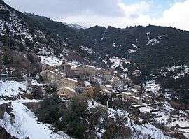
The village of Cargiaca, in the snow | |
 Cargiaca | |
|
Location within Corsica region  Cargiaca | |
| Coordinates: 41°43′54″N 9°02′51″E / 41.7316°N 9.0476°ECoordinates: 41°43′54″N 9°02′51″E / 41.7316°N 9.0476°E | |
| Country | France |
| Region | Corsica |
| Department | Corse-du-Sud |
| Arrondissement | Sartène |
| Canton | Tallano-Scopamène |
| Government | |
| • Mayor (2008–2014) | Don Jacques de Rocca Serra |
| Area1 | 7.87 km2 (3.04 sq mi) |
| Population (2008)2 | 59 |
| • Density | 7.5/km2 (19/sq mi) |
| Time zone | CET (UTC+1) |
| • Summer (DST) | CEST (UTC+2) |
| INSEE/Postal code | 2A066 / 20164 |
| Elevation |
148–1,005 m (486–3,297 ft) (avg. 454 m or 1,490 ft) |
|
1 French Land Register data, which excludes lakes, ponds, glaciers > 1 km² (0.386 sq mi or 247 acres) and river estuaries. 2 Population without double counting: residents of multiple communes (e.g., students and military personnel) only counted once. | |
Cargiaca is a commune in the Corse-du-Sud department of France on the island of Corsica.
Geography
Cargiaca is just to the east of Mont Peloso (974 metres (3,196 ft)).
Population
| Historical population | ||
|---|---|---|
| Year | Pop. | ±% |
| 1962 | 124 | — |
| 1968 | 122 | −1.6% |
| 1975 | 100 | −18.0% |
| 1982 | 90 | −10.0% |
| 1990 | 69 | −23.3% |
| 1999 | 49 | −29.0% |
| 2008 | 59 | +20.4% |
See also
References
| Wikimedia Commons has media related to Cargiaca. |
This article is issued from Wikipedia - version of the 2/11/2016. The text is available under the Creative Commons Attribution/Share Alike but additional terms may apply for the media files.