Cosmorama, São Paulo
| Cosmorama | ||
|---|---|---|
| Municipality | ||
| ||
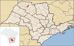 Location of Cosmorama | ||
 Cosmorama Location of Cosmorama | ||
| Coordinates: 20°28′40″S 49°46′40″W / 20.47778°S 49.77778°WCoordinates: 20°28′40″S 49°46′40″W / 20.47778°S 49.77778°W | ||
| Country |
| |
| Region | Southeast | |
| State |
| |
| Area | ||
| • Total | 443.8 km2 (171.4 sq mi) | |
| Elevation | 540 m (1,770 ft) | |
| Population (2010/IBGE) | ||
| • Total | 7,214 | |
| • Density | 16.2/km2 (42/sq mi) | |
| Time zone | UTC-3 (UTC-3) | |
| • Summer (DST) | UTC-2 (UTC-2) | |
| Postal Code | 15530-000 | |
| Area code(s) | +55 17 | |
| Website | Prefecture of Cosmorama | |
Cosmorama is a municipality in the state of São Paulo, Brazil. The city has a population of 7,214 inhabitants and an area of 443.8 km².[1]
Cosmorama belongs to the Mesoregion of São José do Rio Preto.
References
- ↑ "2010 Census of the IBGE - Population - Table 2.1.20" (PDF) (in Portuguese). IBGE.gov.br. Retrieved 12 June 2012.
This article is issued from Wikipedia - version of the 5/15/2016. The text is available under the Creative Commons Attribution/Share Alike but additional terms may apply for the media files.