Coulonges, Vienne
| Coulonges | |
|---|---|
|
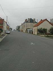
The main street of Hérolles, in Coulonges | |
 Coulonges | |
|
Location within Nouvelle-Aquitaine region  Coulonges | |
| Coordinates: 46°24′12″N 1°09′19″E / 46.4033°N 1.1553°ECoordinates: 46°24′12″N 1°09′19″E / 46.4033°N 1.1553°E | |
| Country | France |
| Region | Nouvelle-Aquitaine |
| Department | Vienne |
| Arrondissement | Montmorillon |
| Canton | Trimouille |
| Intercommunality | Montmorillonnais |
| Government | |
| • Mayor (2008–2014) | Raymond Gallet |
| Area1 | 18.35 km2 (7.08 sq mi) |
| Population (2006)2 | 268 |
| • Density | 15/km2 (38/sq mi) |
| Time zone | CET (UTC+1) |
| • Summer (DST) | CEST (UTC+2) |
| INSEE/Postal code | 86084 / 86290 |
| Elevation |
133–204 m (436–669 ft) (avg. 196 m or 643 ft) |
|
1 French Land Register data, which excludes lakes, ponds, glaciers > 1 km² (0.386 sq mi or 247 acres) and river estuaries. 2 Population without double counting: residents of multiple communes (e.g., students and military personnel) only counted once. | |
Coulonges is a commune in the Vienne department in the Nouvelle-Aquitaine region in western France.
Geography
The river Benaize forms the commune's south-western border.
See also
References
| Wikimedia Commons has media related to Coulonges (Vienne). |
This article is issued from Wikipedia - version of the 11/11/2016. The text is available under the Creative Commons Attribution/Share Alike but additional terms may apply for the media files.