Daluis
| Daluis | ||
|---|---|---|
|
Daluis Gorge of the Var | ||
| ||
 Daluis | ||
|
Location within Provence-A.-C.d'A. region 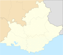 Daluis | ||
| Coordinates: 44°01′28″N 6°48′36″E / 44.0244°N 6.81°ECoordinates: 44°01′28″N 6°48′36″E / 44.0244°N 6.81°E | ||
| Country | France | |
| Region | Provence-Alpes-Côte d'Azur | |
| Department | Alpes-Maritimes | |
| Arrondissement | Nice | |
| Canton | Guillaumes | |
| Intercommunality | Cians Var | |
| Government | ||
| • Mayor (2008–2014) | Paul Nobize | |
| Area1 | 40.03 km2 (15.46 sq mi) | |
| Population (2008)2 | 126 | |
| • Density | 3.1/km2 (8.2/sq mi) | |
| Time zone | CET (UTC+1) | |
| • Summer (DST) | CEST (UTC+2) | |
| INSEE/Postal code | 06053 / 06470 | |
| Elevation |
590–2,502 m (1,936–8,209 ft) (avg. 673 m or 2,208 ft) | |
|
1 French Land Register data, which excludes lakes, ponds, glaciers > 1 km² (0.386 sq mi or 247 acres) and river estuaries. 2 Population without double counting: residents of multiple communes (e.g., students and military personnel) only counted once. | ||
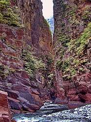

Daluis (Occitan: Daluèis) is a commune in the Alpes-Maritimes department in southeastern France. Situated on the river Var, it is the end point of the Gorges de Daluis.
Population
| Historical population | ||
|---|---|---|
| Year | Pop. | ±% |
| 1962 | 182 | — |
| 1968 | 202 | +11.0% |
| 1975 | 185 | −8.4% |
| 1982 | 124 | −33.0% |
| 1990 | 110 | −11.3% |
| 1999 | 132 | +20.0% |
| 2008 | 126 | −4.5% |
See also
References
| Wikimedia Commons has media related to Daluis. |
This article is issued from Wikipedia - version of the 12/3/2016. The text is available under the Creative Commons Attribution/Share Alike but additional terms may apply for the media files.