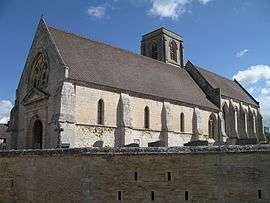
Démouville
| Démouville | |
|---|---|
 | |
 Démouville | |
|
Location within Normandy region 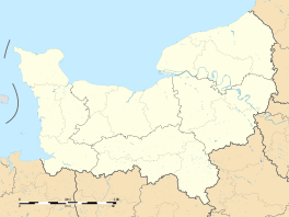 Démouville | |
| Coordinates: 49°10′54″N 0°16′03″W / 49.1817°N 0.2675°WCoordinates: 49°10′54″N 0°16′03″W / 49.1817°N 0.2675°W | |
| Country | France |
| Region | Normandy |
| Department | Calvados |
| Arrondissement | Caen |
| Canton | Troarn |
| Intercommunality | Caen la Mer |
| Government | |
| • Mayor (2008–2014) | Cyrille Laville |
| Area1 | 3.56 km2 (1.37 sq mi) |
| Population (2008)2 | 3,164 |
| • Density | 890/km2 (2,300/sq mi) |
| Time zone | CET (UTC+1) |
| • Summer (DST) | CEST (UTC+2) |
| INSEE/Postal code | 14221 / 14840 |
| Elevation |
13–29 m (43–95 ft) (avg. 19 m or 62 ft) |
|
1 French Land Register data, which excludes lakes, ponds, glaciers > 1 km² (0.386 sq mi or 247 acres) and river estuaries. 2 Population without double counting: residents of multiple communes (e.g., students and military personnel) only counted once. | |
Démouville is a commune in the Calvados department in the Normandy region in northwestern France.
Population
| Historical population | ||
|---|---|---|
| Year | Pop. | ±% |
| 1962 | 788 | — |
| 1968 | 1,045 | +32.6% |
| 1975 | 1,373 | +31.4% |
| 1982 | 2,165 | +57.7% |
| 1990 | 2,495 | +15.2% |
| 1999 | 3,052 | +22.3% |
| 2006 | 3,143 | +3.0% |
| 2008 | 3,164 | +0.7% |
See also
References
| Wikimedia Commons has media related to Démouville. |
This article is issued from Wikipedia - version of the 3/16/2016. The text is available under the Creative Commons Attribution/Share Alike but additional terms may apply for the media files.