Drnholec
| Drnholec | |||
| Market Town | |||
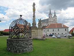 Centrum | |||
|
|||
| Country | Czech Republic | ||
|---|---|---|---|
| Region | South Moravian | ||
| District | Břeclav | ||
| River | Dyje | ||
| Elevation | 183 m (600 ft) | ||
| Coordinates | CZ 48°51′56″N 16°28′43″E / 48.86556°N 16.47861°ECoordinates: CZ 48°51′56″N 16°28′43″E / 48.86556°N 16.47861°E | ||
| Highest point | |||
| - elevation | 226 m (741 ft) | ||
| Area | 35.19 km2 (14 sq mi) | ||
| - land | 33.04 km2 (13 sq mi) | ||
| - water | 2.15 km2 (1 sq mi) | ||
| Population | 1,669 (December 31, 2009[1]) | ||
| Density | 47/km2 (122/sq mi) | ||
| First Mentioned | 1249 | ||
| Mayor | Josef Čápek | ||
| Timezone | CET (UTC+1) | ||
| - summer (DST) | CEST (UTC+2) | ||
| Postal code | 691 83 | ||
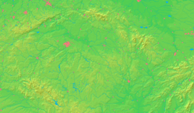  Location in the Czech Republic | |||
| Statistics: www.statnisprava.cz, CZSO Public database | |||
| Website: http://obecdrnholec.cz/ | |||

Drnholec (German: Dürnholz) is a market town in Břeclav District, South Moravian Region, Czech Republic. It has a population of 1,669 (2008).[1]
References
- 1 2 "Vybrané statistické údaje za obec" (in Czech). Czech Statistical Office. Retrieved August 3, 2009.
External links
- (Czech) Official website
| Wikimedia Commons has media related to Drnholec. |
This article is issued from Wikipedia - version of the 10/8/2016. The text is available under the Creative Commons Attribution/Share Alike but additional terms may apply for the media files.