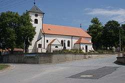
Starovičky
| Starovičky | |||
|---|---|---|---|
| Municipality | |||
 | |||
| |||
 Starovičky | |||
| Coordinates: 48°54′26″N 16°46′4″E / 48.90722°N 16.76778°ECoordinates: 48°54′26″N 16°46′4″E / 48.90722°N 16.76778°E | |||
| Country |
| ||
| Region | South Moravian | ||
| District | Břeclav | ||
| Area | |||
| • Total | 8.58 km2 (3.31 sq mi) | ||
| Elevation | 188 m (617 ft) | ||
| Population (1.1.2012) | |||
| • Total | 822 | ||
| • Density | 96/km2 (250/sq mi) | ||
| Postal code | 693 01 | ||
| Website | http://www.starovicky.cz | ||
Starovičky is a village and municipality (obec) in Břeclav District in the South Moravian Region of the Czech Republic.
The municipality covers an area of 8.58 square kilometres (3.31 sq mi), and has a population of 747 (as at 28 August 2006).
Starovičky lies approximately 19 kilometres (12 mi) north-west of Břeclav, 35 km (22 mi) south of Brno, and 215 km (134 mi) south-east of Prague.
References
| Wikimedia Commons has media related to Starovičky. |
This article is issued from Wikipedia - version of the 4/7/2016. The text is available under the Creative Commons Attribution/Share Alike but additional terms may apply for the media files.