Fullers Crossroads, Alabama
| Fullers Crossroads, Alabama | |
|---|---|
| Unincorporated community | |
 Fullers Crossroads, Alabama  Fullers Crossroads, Alabama | |
| Coordinates: 31°49′05″N 86°18′40″W / 31.81806°N 86.31111°WCoordinates: 31°49′05″N 86°18′40″W / 31.81806°N 86.31111°W | |
| Country | United States |
| State | Alabama |
| County | Crenshaw |
| Elevation | 482 ft (147 m) |
| Time zone | Central (CST) (UTC-6) |
| • Summer (DST) | CDT (UTC-5) |
| Area code(s) | 334 |
| GNIS feature ID | 118750[1] |
Fullers Crossroads is an unincorporated community in Crenshaw County, Alabama, United States.
History
Fullers Crossroads was most likely named for a local family.[2] Fullers Crossroads was one of two choices for the first county seat of Crenshaw County, with Rutledge being chosen based on popular vote.[3] The community maintains a volunteer fire department.[4]
References
- ↑ "Fullers Crossroads". Geographic Names Information System. United States Geological Survey.
- ↑ Foscue, Virginia (1989). Place Names in Alabama. Tuscaloosa: The University of Alabama Press. p. 60. ISBN 0-8173-0410-X.
- ↑ "Early History of Crenshaw County, Alabama". Retrieved 21 December 2014.
- ↑ "Fire Department Listing". Retrieved 21 December 2014.
Municipalities and communities of Crenshaw County, Alabama, United States | ||
|---|---|---|
| Cities | 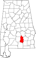 | |
| Towns | ||
| Unincorporated communities | ||
| Footnotes | ‡This populated place also has portions in an adjacent county or counties | |
This article is issued from Wikipedia - version of the 7/31/2016. The text is available under the Creative Commons Attribution/Share Alike but additional terms may apply for the media files.