Theba, Alabama
| Theba, Alabama | |
|---|---|
| Unincorporated community | |
 Theba, Alabama  Theba, Alabama | |
| Coordinates: 31°33′21″N 86°18′13″W / 31.55583°N 86.30361°WCoordinates: 31°33′21″N 86°18′13″W / 31.55583°N 86.30361°W | |
| Country | United States |
| State | Alabama |
| County | Crenshaw |
| Elevation | 289 ft (88 m) |
| Time zone | Central (CST) (UTC-6) |
| • Summer (DST) | CDT (UTC-5) |
| Area code(s) | 334 |
| GNIS feature ID | 155271[1] |
Theba is an unincorporated community in Crenshaw County, Alabama, United States. Theba is located on U.S. Route 29, 3.3 miles (5.3 km) southwest of Brantley.[2]
References
- ↑ "Theba". Geographic Names Information System. United States Geological Survey.
- ↑ General Highway Map: Crenshaw County, Alabama (PDF) (Map). Alabama Department of Transportation. 2007. Retrieved February 14, 2013.
Municipalities and communities of Crenshaw County, Alabama, United States | ||
|---|---|---|
| Cities | 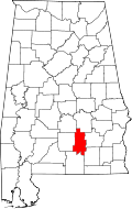 | |
| Towns | ||
| Unincorporated communities | ||
| Footnotes | ‡This populated place also has portions in an adjacent county or counties | |
This article is issued from Wikipedia - version of the 7/31/2016. The text is available under the Creative Commons Attribution/Share Alike but additional terms may apply for the media files.