Gaflenz
| Gaflenz | ||
|---|---|---|
 | ||
| ||
 Gaflenz Location within Austria | ||
| Coordinates: 47°53′49″N 14°43′32″E / 47.89694°N 14.72556°ECoordinates: 47°53′49″N 14°43′32″E / 47.89694°N 14.72556°E | ||
| Country | Austria | |
| State | Upper Austria | |
| District | Steyr-Land | |
| Government | ||
| • Mayor | Guenther Kellnreitner (ÖVP) | |
| Area | ||
| • Total | 59 km2 (23 sq mi) | |
| Elevation | 482 m (1,581 ft) | |
| Population (1 January 2016)[1] | ||
| • Total | 1,924 | |
| • Density | 33/km2 (84/sq mi) | |
| Time zone | CET (UTC+1) | |
| • Summer (DST) | CEST (UTC+2) | |
| Postal code | 3334 | |
| Area code | 07353 | |
| Vehicle registration | SE | |
| Website | www.gaflenz.at | |

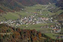
Gaflenz is a market town in the Steyr-Land district of the Austrian state of Upper Austria. It is known for its saws and its gothic-style St. Andreas Parish Church, established in 1494.
Population
| Historical population | ||
|---|---|---|
| Year | Pop. | ±% |
| 1869 | 1,301 | — |
| 1880 | 1,399 | +7.5% |
| 1890 | 1,359 | −2.9% |
| 1900 | 1,427 | +5.0% |
| 1910 | 1,433 | +0.4% |
| 1923 | 1,553 | +8.4% |
| 1934 | 1,504 | −3.2% |
| 1939 | 1,491 | −0.9% |
| 1951 | 1,528 | +2.5% |
| 1961 | 1,520 | −0.5% |
| 1971 | 1,587 | +4.4% |
| 1981 | 1,659 | +4.5% |
| 1991 | 1,677 | +1.1% |
| 2001 | 1,797 | +7.2% |
| 2011 | 1,856 | +3.3% |
International partnerships
Gaflenz is twinned with:
References
External links
| Wikimedia Commons has media related to Gaflenz. |
This article is issued from Wikipedia - version of the 3/6/2014. The text is available under the Creative Commons Attribution/Share Alike but additional terms may apply for the media files.