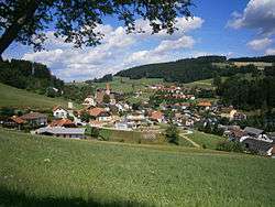
Hirschbach im Mühlkreis
| Hirschbach im Mühlkreis | ||
|---|---|---|
 | ||
| ||
 Hirschbach im Mühlkreis Location within Austria | ||
| Coordinates: 48°29′19″N 14°24′44″E / 48.48861°N 14.41222°ECoordinates: 48°29′19″N 14°24′44″E / 48.48861°N 14.41222°E | ||
| Country | Austria | |
| State | Upper Austria | |
| District | Freistadt | |
| Government | ||
| • Mayor | Stefan Wiesinger (ÖVP) | |
| Area | ||
| • Total | 23.6 km2 (9.1 sq mi) | |
| Elevation | 640 m (2,100 ft) | |
| Population (1 January 2016)[1] | ||
| • Total | 1,149 | |
| • Density | 49/km2 (130/sq mi) | |
| Time zone | CET (UTC+1) | |
| • Summer (DST) | CEST (UTC+2) | |
| Postal code | 4242 | |
| Area code | 07948 | |
| Vehicle registration | FR | |
| Website | www.hirschbach.at | |
Hirschbach im Mühlkreis is a municipality in the district of Freistadt in the Austrian state of Upper Austria.
Population
| Historical population | ||
|---|---|---|
| Year | Pop. | ±% |
| 1869 | 1,146 | — |
| 1880 | 1,119 | −2.4% |
| 1890 | 1,079 | −3.6% |
| 1900 | 1,085 | +0.6% |
| 1910 | 1,190 | +9.7% |
| 1923 | 1,188 | −0.2% |
| 1934 | 1,110 | −6.6% |
| 1939 | 1,056 | −4.9% |
| 1951 | 1,092 | +3.4% |
| 1961 | 1,163 | +6.5% |
| 1971 | 1,186 | +2.0% |
| 1981 | 1,152 | −2.9% |
| 1991 | 1,162 | +0.9% |
| 2001 | 1,186 | +2.1% |
References
| Wikimedia Commons has media related to Hirschbach im Mühlkreis. |
This article is issued from Wikipedia - version of the 3/31/2014. The text is available under the Creative Commons Attribution/Share Alike but additional terms may apply for the media files.