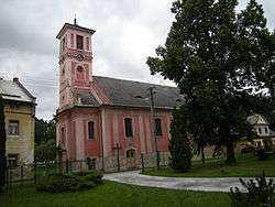
Kobylá nad Vidnavkou
| Kobylá nad Vidnavkou | |||
|---|---|---|---|
| Municipality | |||
 | |||
| |||
 Kobylá nad Vidnavkou | |||
| Coordinates: 50°20′26″N 17°7′16″E / 50.34056°N 17.12111°ECoordinates: 50°20′26″N 17°7′16″E / 50.34056°N 17.12111°E | |||
| Country |
| ||
| Region | Olomouc | ||
| District | Jeseník | ||
| Area | |||
| • Total | 10.82 km2 (4.18 sq mi) | ||
| Elevation | 290 m (950 ft) | ||
| Population (2012) | |||
| • Total | 418 | ||
| • Density | 39/km2 (100/sq mi) | ||
| Postal code | 790 56 | ||
| Website | http://kobyla.rychleby.cz | ||
Kobylá nad Vidnavkou (German Jungferndorf) is a village and municipality (obec) in Jeseník District in the Olomouc Region of the Czech Republic.
The municipality covers an area of 10.82 square kilometres (4.18 sq mi), and has a population of 473 (as at 3 July 2006).
Kobylá nad Vidnavkou lies approximately 14 kilometres (9 mi) north-west of Jeseník, 84 km (52 mi) north of Olomouc, and 195 km (121 mi) east of Prague.
References
| Wikimedia Commons has media related to Kobylá nad Vidnavkou. |
This article is issued from Wikipedia - version of the 4/7/2016. The text is available under the Creative Commons Attribution/Share Alike but additional terms may apply for the media files.