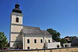
Krenglbach
| Krenglbach | ||
|---|---|---|
 | ||
| ||
 Krenglbach Location within Austria | ||
| Coordinates: 48°12′14″N 13°57′25″E / 48.20389°N 13.95694°ECoordinates: 48°12′14″N 13°57′25″E / 48.20389°N 13.95694°E | ||
| Country | Austria | |
| State | Upper Austria | |
| District | Wels-Land | |
| Government | ||
| • Mayor | Johann Zauner-Penninger (SPÖ) | |
| Area | ||
| • Total | 15 km2 (6 sq mi) | |
| Elevation | 310 m (1,020 ft) | |
| Population (14 June 2016)[1] | ||
| • Total | 3,076 | |
| • Density | 210/km2 (530/sq mi) | |
| Time zone | CET (UTC+1) | |
| • Summer (DST) | CEST (UTC+2) | |
| Postal code | 4631 | |
| Area code | 07249 | |
| Vehicle registration | WL | |
| Website | www.krenglbach.at | |
Krenglbach is a municipality in the district of Wels-Land in the Austrian state of Upper Austria.
Population
| Historical population | ||
|---|---|---|
| Year | Pop. | ±% |
| 1991 | 2,384 | — |
| 2001 | 2,644 | +10.9% |
| 2007 | 3,073 | +16.2% |
References
| Wikimedia Commons has media related to Krenglbach. |
This article is issued from Wikipedia - version of the 3/7/2014. The text is available under the Creative Commons Attribution/Share Alike but additional terms may apply for the media files.