Pennewang
| Pennewang | ||
|---|---|---|
 | ||
| ||
 Pennewang Location within Austria | ||
| Coordinates: 48°07′46″N 13°50′38″E / 48.12944°N 13.84389°ECoordinates: 48°07′46″N 13°50′38″E / 48.12944°N 13.84389°E | ||
| Country | Austria | |
| State | Upper Austria | |
| District | Wels-Land | |
| Government | ||
| • Mayor | Hermann Lidauer (ÖVP) | |
| Area | ||
| • Total | 18 km2 (7 sq mi) | |
| Elevation | 396 m (1,299 ft) | |
| Population (14 June 2016)[1] | ||
| • Total | 901 | |
| • Density | 50/km2 (130/sq mi) | |
| Time zone | CET (UTC+1) | |
| • Summer (DST) | CEST (UTC+2) | |
| Postal code | 4624 | |
| Area codes | 0 72 45 | |
| Vehicle registration | WL | |
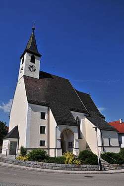
Pennewang is a municipality in the district of Wels-Land in the Austrian state of Upper Austria.
Population
| Historical population | ||
|---|---|---|
| Year | Pop. | ±% |
| 1991 | 813 | — |
| 2001 | 859 | +5.7% |
References
| Wikimedia Commons has media related to Pennewang. |
This article is issued from Wikipedia - version of the 3/7/2014. The text is available under the Creative Commons Attribution/Share Alike but additional terms may apply for the media files.