Nohead Bottom, Virginia
| Nohead Bottom, Virginia | |
|---|---|
| Unincorporated community | |
 Nohead Bottom, Virginia  Nohead Bottom, Virginia | |
| Coordinates: 37°35′36″N 76°29′58″W / 37.59333°N 76.49944°WCoordinates: 37°35′36″N 76°29′58″W / 37.59333°N 76.49944°W | |
| Country | United States |
| State | Virginia |
| County | Middlesex |
| Elevation | 79 ft (24 m) |
| Time zone | Eastern (EST) (UTC-5) |
| • Summer (DST) | EDT (UTC-4) |
| GNIS feature ID | 1499804[1] |
Nohead Bottom is an unincorporated community in Middlesex County, Virginia, United States. It was also known as Nohead.
References
Municipalities and communities of Middlesex County, Virginia, United States | ||
|---|---|---|
| Town | 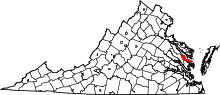 | |
| CDPs | ||
| Unincorporated communities | ||
| Footnotes | ‡This populated place also has portions in an adjacent county or counties | |
This article is issued from Wikipedia - version of the 7/27/2016. The text is available under the Creative Commons Attribution/Share Alike but additional terms may apply for the media files.