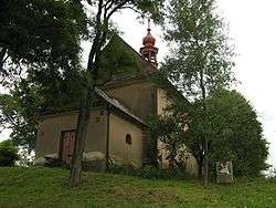
Opatovec
| Opatovec | |||
|---|---|---|---|
| Municipality | |||
 | |||
| |||
 Opatovec | |||
| Coordinates: 49°48′10″N 16°28′47″E / 49.80278°N 16.47972°ECoordinates: 49°48′10″N 16°28′47″E / 49.80278°N 16.47972°E | |||
| Country |
| ||
| Region | Pardubice | ||
| District | Svitavy | ||
| Area | |||
| • Total | 7.07 km2 (2.73 sq mi) | ||
| Elevation | 438 m (1,437 ft) | ||
| Population (1.1.2014) | |||
| • Total | 671 | ||
| • Density | 95/km2 (250/sq mi) | ||
| Postal code | 568 02 | ||

Opatovec (German Überdörfel) is a village and municipality (obec) in Svitavy District in the Pardubice Region of the Czech Republic.
The municipality covers an area of 7.07 square kilometres (2.73 sq mi), and has a population of 612 (as at 28 August 2006).
Opatovec lies approximately 6 kilometres (4 mi) north of Svitavy, 57 km (35 mi) south-east of Pardubice, and 151 km (94 mi) east of Prague.
References
| Wikimedia Commons has media related to Opatovec. |
This article is issued from Wikipedia - version of the 4/7/2016. The text is available under the Creative Commons Attribution/Share Alike but additional terms may apply for the media files.