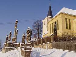
Kunčina
| Kunčina | |||
|---|---|---|---|
| Municipality | |||
 | |||
| |||
 Kunčina | |||
| Coordinates: 49°47′41″N 16°37′42″E / 49.79472°N 16.62833°ECoordinates: 49°47′41″N 16°37′42″E / 49.79472°N 16.62833°E | |||
| Country |
| ||
| Region | Pardubice | ||
| District | Svitavy | ||
| Area | |||
| • Total | 22.67 km2 (8.75 sq mi) | ||
| Elevation | 365 m (1,198 ft) | ||
| Population (1.1.2014) | |||
| • Total | 1,377 | ||
| • Density | 61/km2 (160/sq mi) | ||
| Postal code | 569 24 | ||
| Website | http://www.obeckuncina.cz | ||
Kunčina is a village and municipality (obec) in Svitavy District in the Pardubice Region of the Czech Republic.
The municipality covers an area of 22.67 square kilometres (8.75 sq mi), and has a population of 1,225 (as at 28 August 2006).
Kunčina lies approximately 13 kilometres (8 mi) east of Svitavy, 67 km (42 mi) south-east of Pardubice, and 162 km (101 mi) east of Prague.
References
| Wikimedia Commons has media related to Kunčina. |
This article is issued from Wikipedia - version of the 4/7/2016. The text is available under the Creative Commons Attribution/Share Alike but additional terms may apply for the media files.