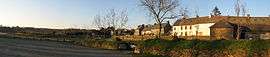
Pouldouran
| Pouldouran Pouldouran | ||
|---|---|---|
 | ||
| ||
 Pouldouran | ||
|
Location within Brittany region 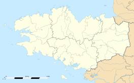 Pouldouran | ||
| Coordinates: 48°45′55″N 3°11′52″W / 48.7653°N 3.1978°WCoordinates: 48°45′55″N 3°11′52″W / 48.7653°N 3.1978°W | ||
| Country | France | |
| Region | Brittany | |
| Department | Côtes-d'Armor | |
| Arrondissement | Lannion | |
| Canton | La Roche-Derrien | |
| Intercommunality | Pays Rochois | |
| Government | ||
| • Mayor (2014–2020) | Hervé Lintanf | |
| Area1 | 1.02 km2 (0.39 sq mi) | |
| Population (2008)2 | 152 | |
| • Density | 150/km2 (390/sq mi) | |
| Time zone | CET (UTC+1) | |
| • Summer (DST) | CEST (UTC+2) | |
| INSEE/Postal code | 22253 / 22450 | |
| Elevation | 0–50 m (0–164 ft) | |
|
1 French Land Register data, which excludes lakes, ponds, glaciers > 1 km² (0.386 sq mi or 247 acres) and river estuaries. 2 Population without double counting: residents of multiple communes (e.g., students and military personnel) only counted once. | ||
.svg.png)
Pouldouran (Breton: Pouldouran) is a commune in the Côtes-d'Armor department of Brittany in northwestern France.
Population
| Historical population | ||
|---|---|---|
| Year | Pop. | ±% |
| 1962 | 188 | — |
| 1968 | 212 | +12.8% |
| 1975 | 162 | −23.6% |
| 1982 | 145 | −10.5% |
| 1990 | 146 | +0.7% |
| 1999 | 160 | +9.6% |
| 2008 | 152 | −5.0% |
Inhabitants of Pouldouran are called pouldourannais in French.
Breton language
The municipality launched a linguistic plan through Ya d'ar brezhoneg on November 25, 2005.
See also
References
| Wikimedia Commons has media related to Pouldouran. |
This article is issued from Wikipedia - version of the 2/11/2016. The text is available under the Creative Commons Attribution/Share Alike but additional terms may apply for the media files.