Saint-Lattier
| Saint-Lattier | |
|---|---|
|
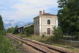
Train station | |
 Saint-Lattier | |
|
Location within Auvergne-Rhône-Alpes region  Saint-Lattier | |
| Coordinates: 45°05′19″N 5°12′05″E / 45.0886°N 5.2014°ECoordinates: 45°05′19″N 5°12′05″E / 45.0886°N 5.2014°E | |
| Country | France |
| Region | Auvergne-Rhône-Alpes |
| Department | Isère |
| Arrondissement | Grenoble |
| Canton | Saint-Marcellin |
| Intercommunality | Pays de Saint-Marcellin |
| Government | |
| • Mayor (2014–2020) | Raymond Payen |
| Area1 | 18.17 km2 (7.02 sq mi) |
| Population (2011)2 | 1,267 |
| • Density | 70/km2 (180/sq mi) |
| Time zone | CET (UTC+1) |
| • Summer (DST) | CEST (UTC+2) |
| INSEE/Postal code | 38410 / 38840 |
| Elevation |
144–406 m (472–1,332 ft) (avg. 178 m or 584 ft) |
|
1 French Land Register data, which excludes lakes, ponds, glaciers > 1 km² (0.386 sq mi or 247 acres) and river estuaries. 2 Population without double counting: residents of multiple communes (e.g., students and military personnel) only counted once. | |
Saint-Lattier is a commune in the Isère department in southeastern France.
Population
| Historical population | ||
|---|---|---|
| Year | Pop. | ±% |
| 1793 | 1,140 | — |
| 1806 | 1,288 | +13.0% |
| 1821 | 1,423 | +10.5% |
| 1831 | 1,558 | +9.5% |
| 1841 | 1,709 | +9.7% |
| 1851 | 1,769 | +3.5% |
| 1861 | 1,661 | −6.1% |
| 1872 | 1,651 | −0.6% |
| 1881 | 1,505 | −8.8% |
| 1891 | 1,430 | −5.0% |
| 1901 | 1,400 | −2.1% |
| 1911 | 1,276 | −8.9% |
| 1921 | 1,162 | −8.9% |
| 1931 | 934 | −19.6% |
| 1946 | 850 | −9.0% |
| 1954 | 896 | +5.4% |
| 1962 | 870 | −2.9% |
| 1968 | 833 | −4.3% |
| 1975 | 775 | −7.0% |
| 1982 | 902 | +16.4% |
| 1990 | 1,028 | +14.0% |
| 1999 | 1,031 | +0.3% |
| 2006 | 1,192 | +15.6% |
| 2011 | 1,267 | +6.3% |
See also
References
| Wikimedia Commons has media related to Saint-Lattier. |
This article is issued from Wikipedia - version of the 10/28/2016. The text is available under the Creative Commons Attribution/Share Alike but additional terms may apply for the media files.