Sankt Martin im Mühlkreis
| Sankt Martin im Mühlkreis | ||
|---|---|---|
|
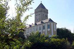
Neuhaus castle | ||
| ||
 Sankt Martin im Mühlkreis Location within Austria | ||
| Coordinates: 48°25′00″N 14°02′21″E / 48.41667°N 14.03917°ECoordinates: 48°25′00″N 14°02′21″E / 48.41667°N 14.03917°E | ||
| Country | Austria | |
| State | Upper Austria | |
| District | Rohrbach | |
| Government | ||
| • Mayor | Wolfgang Schirz (ÖVP) | |
| Area | ||
| • Total | 35 km2 (14 sq mi) | |
| Elevation | 549 m (1,801 ft) | |
| Population (14 June 2016)[1] | ||
| • Total | 3,682 | |
| • Density | 110/km2 (270/sq mi) | |
| Time zone | CET (UTC+1) | |
| • Summer (DST) | CEST (UTC+2) | |
| Postal code | 4113 | |
| Area code | 07232 | |
| Vehicle registration | RO | |
| Website | www.sankt-martin.at | |
Sankt Martin im Mühlkreis is a municipality in the district of Rohrbach in the Austrian state of Upper Austria.
Population
| Historical population | ||
|---|---|---|
| Year | Pop. | ±% |
| 1869 | 2,068 | — |
| 1880 | 2,109 | +2.0% |
| 1890 | 2,197 | +4.2% |
| 1900 | 2,201 | +0.2% |
| 1910 | 2,314 | +5.1% |
| 1923 | 2,251 | −2.7% |
| 1934 | 2,301 | +2.2% |
| 1939 | 2,198 | −4.5% |
| 1951 | 2,094 | −4.7% |
| 1961 | 2,197 | +4.9% |
| 1971 | 2,359 | +7.4% |
| 1981 | 2,725 | +15.5% |
| 1991 | 3,239 | +18.9% |
| 2001 | 3,588 | +10.8% |
| 2011 | 3,612 | +0.7% |
References
- ↑ Statistik Austria - Bevölkerung zu Jahresbeginn 2002-2016 nach Gemeinden, Erstellt am 14.06.2016 (Last accessed 13.12.2016) for Sankt Martin im Mühlkreis.
| Wikimedia Commons has media related to Sankt Martin im Mühlkreis. |
This article is issued from Wikipedia - version of the 3/5/2014. The text is available under the Creative Commons Attribution/Share Alike but additional terms may apply for the media files.