Sankt Peter am Ottersbach
| Sankt Peter am Ottersbach | ||
|---|---|---|
 | ||
| ||
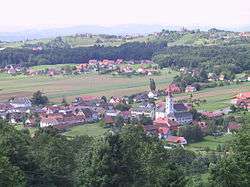
 Sankt Peter am Ottersbach Location within Austria | ||
| Coordinates: 46°47′52″N 15°45′33″E / 46.79778°N 15.75917°ECoordinates: 46°47′52″N 15°45′33″E / 46.79778°N 15.75917°E | ||
| Country | Austria | |
| State | Styria | |
| District | Südoststeiermark | |
| Government | ||
| • Mayor | Franz Thuswohl (ÖVP) | |
| Area | ||
| • Total | 35.48 km2 (13.70 sq mi) | |
| Elevation | 380 m (1,250 ft) | |
| Population (1 January 2016)[1] | ||
| • Total | 2,261 | |
| • Density | 64/km2 (170/sq mi) | |
| Time zone | CET (UTC+1) | |
| • Summer (DST) | CEST (UTC+2) | |
| Postal code | 8093 | |
| Area code | 03477 | |
| Vehicle registration | RA | |
| Website | www.stpeter-weindorf.at | |

Sankt Peter am Ottersbach is a municipality in the district of Südoststeiermark in the Austrian state of Styria.
Population
| Historical population | ||
|---|---|---|
| Year | Pop. | ±% |
| 1869 | 3,003 | — |
| 1880 | 2,998 | −0.2% |
| 1890 | 2,945 | −1.8% |
| 1900 | 2,843 | −3.5% |
| 1910 | 2,918 | +2.6% |
| 1923 | 2,795 | −4.2% |
| 1934 | 2,811 | +0.6% |
| 1939 | 2,742 | −2.5% |
| 1951 | 2,784 | +1.5% |
| 1961 | 2,567 | −7.8% |
| 1971 | 2,685 | +4.6% |
| 1981 | 2,626 | −2.2% |
| 1991 | 2,477 | −5.7% |
| 2001 | 2,357 | −4.8% |
| 2012 | 2,261 | −4.1% |
References
- ↑ Statistik Austria - Bevölkerung zu Jahresbeginn 2002-2016 nach Gemeinden (Gebietsstand 1.1.2016) for Sankt Peter am Ottersbach.
This article is issued from Wikipedia - version of the 12/31/2013. The text is available under the Creative Commons Attribution/Share Alike but additional terms may apply for the media files.