Sunset, Washington County, Arkansas
| Sunset, Arkansas | |
|---|---|
| Unincorporated community | |
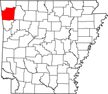
 Sunset, Arkansas Sunset's position in Arkansas. | |
| Coordinates: 35°48′37.3″N 94°00′47.7″W / 35.810361°N 94.013250°WCoordinates: 35°48′37.3″N 94°00′47.7″W / 35.810361°N 94.013250°W | |
| Country |
|
| State |
|
| County | Washington |
| Township | Reed |
| Elevation | 694 m (2,277 ft) |
| Time zone | Central (CST) (UTC-6) |
| • Summer (DST) | CDT (UTC-5) |
| ZIP code | 72959 |
| Area code(s) | 479 |
| GNIS feature ID | 78505 |
| U.S. Geological Survey Geographic Names Information System: Sunset, Washington County, Arkansas | |
See also: Sunset, Arkansas
Sunset (formerly Sun Set) is an unincorporated community in Reed Township, Washington County, Arkansas, United States.[1] It is located at the intersection of Sunset Road (Washington County Road 38 [CR 38]) and CR 110.[2]
History
The community had a post office according to an 1894 map of the county.[3]
References
- ↑ "Sunset, Arkansas". Geographic Names Information System. United States Geological Survey.
- ↑ Arkansas Atlas and Gazetteer (Map) (Second ed.). DeLorme. § 30.
- ↑ "Township 13 N. Range 29 W., Brentwood, Harris, Sunset" (Map). Washington County. Cedar Rapids, Iowa: Gordon V. Skelton. 1894. LCCN unk81004385.
This article is issued from Wikipedia - version of the 2/11/2014. The text is available under the Creative Commons Attribution/Share Alike but additional terms may apply for the media files.