Záchlumí (Tachov District)
| Záchlumí | |||
|---|---|---|---|
| Municipality | |||
 | |||
| |||
 Záchlumí | |||
| Coordinates: 49°47′51″N 12°57′50″E / 49.79750°N 12.96389°ECoordinates: 49°47′51″N 12°57′50″E / 49.79750°N 12.96389°E | |||
| Country |
| ||
| Region | Plzeň | ||
| District | Tachov | ||
| Area | |||
| • Total | 4.41 km2 (1.70 sq mi) | ||
| Elevation | 497 m (1,631 ft) | ||
| Population (2006) | |||
| • Total | 408 | ||
| • Density | 93/km2 (240/sq mi) | ||
| Postal code | 349 01 | ||
| Website | http://www.zachlumi.cz | ||
_vlajka.jpg)
_znak.jpg)
Záchlumí (German Eisenhuttel) is a village and municipality (obec) in Tachov District in the Plzeň Region of the Czech Republic.
The municipality covers an area of 4.41 square kilometres (1.70 sq mi), and has a population of 408 (as at 3 July 2006).
Záchlumí lies approximately 25 kilometres (16 mi) east of Tachov, 31 km (19 mi) west of Plzeň, and 110 km (68 mi) west of Prague.
Gallery
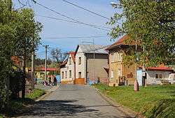
 Middle part
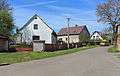
- Tenement houses
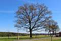 Old oak – protected tree
References
| Wikimedia Commons has media related to Záchlumí (Tachov District). |
This article is issued from Wikipedia - version of the 9/12/2016. The text is available under the Creative Commons Attribution/Share Alike but additional terms may apply for the media files.