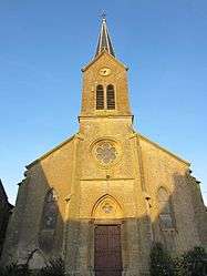
Affléville
| Affléville | ||
|---|---|---|
 | ||
| ||
 Affléville | ||
|
Location within Grand Est region 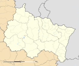 Affléville | ||
| Coordinates: 49°16′14″N 5°45′51″E / 49.2706°N 5.7642°ECoordinates: 49°16′14″N 5°45′51″E / 49.2706°N 5.7642°E | ||
| Country | France | |
| Region | Grand Est | |
| Department | Meurthe-et-Moselle | |
| Arrondissement | Briey | |
| Canton | Conflans-en-Jarnisy | |
| Intercommunality | Jarnisy | |
| Government | ||
| • Mayor (2008–2014) | Patrick Martin | |
| Area1 | 9.42 km2 (3.64 sq mi) | |
| Population (2009)2 | 201 | |
| • Density | 21/km2 (55/sq mi) | |
| Time zone | CET (UTC+1) | |
| • Summer (DST) | CEST (UTC+2) | |
| INSEE/Postal code | 004 54 004 / 54 800 | |
| Elevation |
237–286 m (778–938 ft) (avg. 254 m or 833 ft) | |
|
1 French Land Register data, which excludes lakes, ponds, glaciers > 1 km² (0.386 sq mi or 247 acres) and river estuaries. 2 Population without double counting: residents of multiple communes (e.g., students and military personnel) only counted once. | ||

Affléville is a commune in the Meurthe-et-Moselle department in northeastern France.
Geography
The river Othain flows northwestward through the western part of the commune.
Population
| Historical population | ||
|---|---|---|
| Year | Pop. | ±% |
| 1962 | 224 | — |
| 1968 | 196 | −12.5% |
| 1975 | 163 | −16.8% |
| 1982 | 179 | +9.8% |
| 1990 | 185 | +3.4% |
| 1999 | 196 | +5.9% |
| 2006 | 201 | +2.6% |
| 2009 | 201 | +0.0% |
Inhabitants are called Afflévillois.
See also
References
| Wikimedia Commons has media related to Affléville. |
This article is issued from Wikipedia - version of the 3/15/2016. The text is available under the Creative Commons Attribution/Share Alike but additional terms may apply for the media files.