Bussière-Badil
| Bussière-Badil | ||
|---|---|---|
 | ||
| ||
 Bussière-Badil | ||
|
Location within Nouvelle-Aquitaine region  Bussière-Badil | ||
| Coordinates: 45°39′09″N 0°36′22″E / 45.6525°N 0.6061°ECoordinates: 45°39′09″N 0°36′22″E / 45.6525°N 0.6061°E | ||
| Country | France | |
| Region | Nouvelle-Aquitaine | |
| Department | Dordogne | |
| Arrondissement | Nontron | |
| Canton | Bussière-Badil | |
| Intercommunality | Périgord Vert Granitique | |
| Government | ||
| • Mayor (2008–2014) | Jean-Pierre Terrefond | |
| Area1 | 19.86 km2 (7.67 sq mi) | |
| Population (2008)2 | 483 | |
| • Density | 24/km2 (63/sq mi) | |
| Time zone | CET (UTC+1) | |
| • Summer (DST) | CEST (UTC+2) | |
| INSEE/Postal code | 24071 / 24360 | |
| Elevation |
125–292 m (410–958 ft) (avg. 190 m or 620 ft) | |
|
1 French Land Register data, which excludes lakes, ponds, glaciers > 1 km² (0.386 sq mi or 247 acres) and river estuaries. 2 Population without double counting: residents of multiple communes (e.g., students and military personnel) only counted once. | ||
.svg.png)
Bussière-Badil is a commune in the Dordogne department in southwestern France, part of the Parc naturel régional Périgord Limousin.
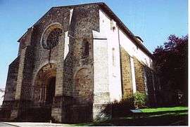
The place is first mentioned in 768 when the Order of Saint Benedict built a priory there. The Romanesque art-style church was built in the 12th century.
Population
| Historical population | ||
|---|---|---|
| Year | Pop. | ±% |
| 1864 | 1,293 | — |
| 1962 | 645 | −50.1% |
| 1968 | 584 | −9.5% |
| 1975 | 595 | +1.9% |
| 1982 | 540 | −9.2% |
| 1990 | 530 | −1.9% |
| 1999 | 523 | −1.3% |
| 2008 | 483 | −7.6% |
See also
References
| Wikimedia Commons has media related to Bussière-Badil. |
This article is issued from Wikipedia - version of the 2/11/2016. The text is available under the Creative Commons Attribution/Share Alike but additional terms may apply for the media files.