Caibaté
| Caibaté | |
|---|---|
| Municipality | |
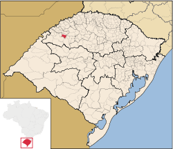 Location in Rio Grande do Sul state | |
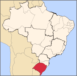
 Caibaté Location in Brazil | |
| Coordinates: 28°17′16″S 54°38′16″W / 28.28778°S 54.63778°WCoordinates: 28°17′16″S 54°38′16″W / 28.28778°S 54.63778°W | |
| Country |
|
| State | Rio Grande do Sul |
| Area | |
| • Total | 259.66 km2 (100.26 sq mi) |
| Elevation | 286 m (938 ft) |
| Population (2015) | |
| • Total | 5,058 |
| • Density | 19/km2 (50/sq mi) |
| Time zone | BRT (UTC-3) |
| • Summer (DST) | BRST (UTC-2) |
| Postal code | 97930-xxx |
| Website |
www |
Caibaté is a municipality of the state of Rio Grande do Sul, Brazil. The population is 5,058 (2015 est.) in an area of 259.66 km².[1] The name comes from the Tupi language. It is located 524 km west of the state capital of Porto Alegre, northeast of Alegrete.
Bounding municipalities
References
External links
- http://www.citybrazil.com.br/rs/caibate/ (Portuguese)
This article is issued from Wikipedia - version of the 9/4/2016. The text is available under the Creative Commons Attribution/Share Alike but additional terms may apply for the media files.