Caurel, Côtes-d'Armor
| Caurel Kaorel | |
|---|---|
|
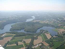
Lake of Guerledan | |
 Caurel | |
|
Location within Brittany region  Caurel | |
| Coordinates: 48°13′01″N 3°02′14″W / 48.2169°N 3.0372°WCoordinates: 48°13′01″N 3°02′14″W / 48.2169°N 3.0372°W | |
| Country | France |
| Region | Brittany |
| Department | Côtes-d'Armor |
| Arrondissement | Guingamp |
| Canton | Mûr-de-Bretagne |
| Intercommunality | Guerdelan Mûr–de-Bretagne |
| Government | |
| • Mayor (2014–2020) | Jean-Louis Martigné |
| Area1 | 11.65 km2 (4.50 sq mi) |
| Population (2008)2 | 384 |
| • Density | 33/km2 (85/sq mi) |
| Time zone | CET (UTC+1) |
| • Summer (DST) | CEST (UTC+2) |
| INSEE/Postal code | 22033 / 22530 |
| Elevation | 120–308 m (394–1,010 ft) |
|
1 French Land Register data, which excludes lakes, ponds, glaciers > 1 km² (0.386 sq mi or 247 acres) and river estuaries. 2 Population without double counting: residents of multiple communes (e.g., students and military personnel) only counted once. | |
Caurel (Breton: Kaorel) is a commune in the Côtes-d'Armor department of Brittany in northwestern France.
Population
| Historical population | ||
|---|---|---|
| Year | Pop. | ±% |
| 1962 | 342 | — |
| 1968 | 434 | +26.9% |
| 1975 | 358 | −17.5% |
| 1982 | 376 | +5.0% |
| 1990 | 384 | +2.1% |
| 1999 | 387 | +0.8% |
| 2008 | 384 | −0.8% |
Inhabitants of Caurel are called Caurelois in French and Kaoreliz in Breton.
See also
References
External links
| Wikimedia Commons has media related to Caurel (Côtes-d'Armor). |
This article is issued from Wikipedia - version of the 3/15/2016. The text is available under the Creative Commons Attribution/Share Alike but additional terms may apply for the media files.