Eaux-Puiseaux
| Eaux-Puiseaux | |
|---|---|
 | |
 Eaux-Puiseaux | |
|
Location within Grand Est region 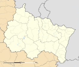 Eaux-Puiseaux | |
| Coordinates: 48°07′15″N 3°53′30″E / 48.1208°N 3.8918°ECoordinates: 48°07′15″N 3°53′30″E / 48.1208°N 3.8918°E | |
| Country | France |
| Region | Grand Est |
| Department | Aube |
| Arrondissement | Troyes |
| Canton | Ervy-le-Châtel |
| Intercommunality | Région du val d'Armance |
| Government | |
| • Mayor (2008–2014) | Pierre Jacquis |
| Area1 | 8.61 km2 (3.32 sq mi) |
| Population (2008)2 | 234 |
| • Density | 27/km2 (70/sq mi) |
| Time zone | CET (UTC+1) |
| • Summer (DST) | CEST (UTC+2) |
| INSEE/Postal code | 10133 / 10130 |
| Elevation |
157–280 m (515–919 ft) (avg. 220 m or 720 ft) |
|
1 French Land Register data, which excludes lakes, ponds, glaciers > 1 km² (0.386 sq mi or 247 acres) and river estuaries. 2 Population without double counting: residents of multiple communes (e.g., students and military personnel) only counted once. | |
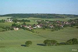
Eaux-Puiseaux is a commune in the Aube department in north-central France.
Eaux-Puiseaux is situated about 35 km from Troyes and 50 km from Auxerre, in the canton of Ervy-le-Châtel. The RN77 road passes close to the village.
Population
| Historical population | ||
|---|---|---|
| Year | Pop. | ±% |
| 1962 | 248 | — |
| 1968 | 216 | −12.9% |
| 1975 | 186 | −13.9% |
| 1982 | 186 | +0.0% |
| 1990 | 172 | −7.5% |
| 1999 | 194 | +12.8% |
| 2008 | 234 | +20.6% |
See also
References
| Wikimedia Commons has media related to Eaux-Puiseaux. |
This article is issued from Wikipedia - version of the 6/11/2013. The text is available under the Creative Commons Attribution/Share Alike but additional terms may apply for the media files.